


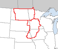
The areas outlined in red represent a Tornado Watch area that was just issued by the national weather service. The area covers portions of five midwest states. Tornadoes, 80 mile per hour winds and up to three inch hail possible in the Twin Cities.
According to the NWS:
THUNDERSTORMS ARE EXPECTED TO RAPIDLY INTENSIFY THISKeep your eyes open. This could get interesting.
AFTERNOON OVER EXTREME EASTERN SD/EASTERN NEB AND TRACK EASTWARD
INTO PARTS OF MN/IA. SHEAR PROFILES ARE FAVORABLE FOR SUPERCELLS
CAPABLE OF VERY LARGE HAIL...DAMAGING WINDS...AND A FEW TORNADOES.
STORMS ARE EXPECTED TO EVENTUALLY ORGANIZE INTO A SQUALL LINE AND
SPREAD ACROSS THE WATCH AREA THIS EVENING.
~Kirk

0 comments:
Post a Comment